


The Road to Bromo, part 2
continued from the Road to Bromo
The road trip from Bali to Surabaya was a spur of the moment. A friend told me that she and her husband had some business in Surabaya and invited me to go with them by car. We would just share expenses. The following day, the decision was made. I canceled my Bali-Surabaya plane ticket and bought a road map.
April 11, 2008
Planning the road trip was not hard. The internet is such a divine source of information. After studying the route, I realized one thing – Bromo is just about the only significant tourist destination in east of Surabaya. So Bromo here we come!
We covered the 160km stretch from Nusa Dua (South Bali) to Gilimanuk in Negara (West Bali) in 4 hours. I have to admit I was the drag as we made a stop at Tabanan for I photographed some terraces during sunrise. I also got curious and we swung by Pura Tampaksiring in Negara.
The 30 minute ferry ride from Gilimanuk to Banyuwangi was non-eventful. There was no traffic, no queue. It helped that it was 9AM. I hear that late afternoon and dawn crowds can get heavy so we missed those. We paid almost $10 for the car and extra fare for 2 persons as only the driver was free.
There is some 196km distance between the port of Banyuwangi and the city of Probolinggo where Bromo is. The national highway is, not surprisingly, smoothly paved as this is a major artery connecting the populated islands of Java and Bali. We did not get lost. I played navigator and with the map, I clicked off the towns one by one. At Penjaitan, I kept on looking out for a tea plantation but either it really was not there or it was nondescript and unmarked. Too bad. There was one other major city that we passed, Situbondo, but aside from the ubiquitous mosques, ricefields and farms, we did not see any cause to stop except to inflate a semi-flat tire and to have a Masakan Padang lunch in Pasir Putih, which obviously is a popular spot in the area gauging from the density of resorts.
Once we reached Probolinggo, we headed south and followed the road markers to Bromo. As we climbed further up, the weather also began to change. Altitude does that to a place. Vegetation changes. Instead of rice, we began to see more cold-dwelling vegetable and flower farms and orchards. Palms turned into pines. The road slowly became more narrow and the traffic came to a trickle. There were no more large buses. The only local transportation are the bemohs, which are medium-sized vans and even then, they were rare. Apparently, locals can catch them at a terminal in Probolinggo. (For backpackers, sorry, I don’t know the fare and other details on frequency and stops). What also appeared on paper as a mere 30 kilometer turned out to be more because of the elevation. The ride became more bumpy, more difficult and more treacherous as we slowly scaled some 1,800 meters above sea level, probably even more until we reached the final 2 towns of Ngadisari and Cemara Lawang.
If you’d like to drive on your own without prior knowledge or a local guide like we did, there are imminent safety concerns:
(1) Landslides are frequent in the Sukarapura-Sapikerep-Ngadisari- Cemara Lawang highlands as evidenced by the four or five recently repaired sections that we passed by, two of which are still actively being reinforced by the public works personnel.
(2) Unexpected rain and heavy fog can swoop unexpectedly anytime. We had to drive slow when driving visibility shrank to five meters or so.
(3) Roads are bordered by steep mountain in one side and deep ravines in the other.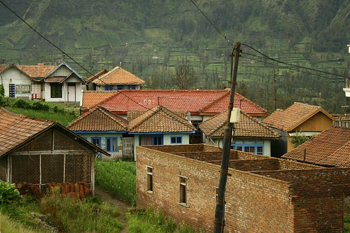
Canon EOS 350D Digital, 1/250s, f/5.6, 55mm, ISO 100
typical brick houses of Cemara Lawang, Probolinggo, East Java, Indonesia
The town of Sukarapura, about an hour ride from Cemara Lawang, is already dotted with several hostels and lodging houses. We skipped them. Upon reaching Ngadisari though, we were stopped at a community road block whereupon we were asked that a guide would already be necessary to reach Cemara Lawang. I am not sure whether this was compulsory but looking back, a guide is indispensable to visit Bromo so this place was as good as any in getting one. The guide offered us two accommodation options: lodging in Ngadisari (cheaper) or in Cemara Lawang. I opted for the latter which is where the entrance of the Bromo National Park is. Hey, the nearer to Bromo, the better.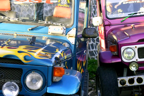
Canon EOS 350D Digital, 20s, f/16, 18mm, ISO 100
colorful hard top jeeps of the Bromo National Park, Probolinggo-Pasuruan, East Java, Indonesia
My friend squeezed out a deal of around 325,000Rp ($35) for an accompanied sunrise tour to Bromo the next morning inclusive of the prerequisite hardtop jeep transport from the crater to the Mt. Penanjakan mountain viewpoint. The Bromo National Park authorities only allows this official transport to traverse the crater towards Mt. Penanjakan, even if you bring the latest 4x4. The $35 deal already covered all three of us so it was not usurious (the jeep can actually carry 5 at most).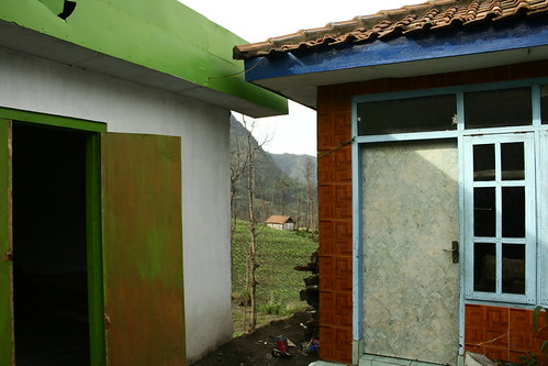
Canon EOS 350D Digital, 1/200s, f/5.6, 18mm, ISO 100, _1/3EV
typical brightly colored houses in Cemara Lawang, Probolinggo, East Java, Indonesia
From Ngadisari, drove to Cemara Lawang, while the guide followed us on a motorbike (he later would rent an official 4x4 for the tour). The 6km distance covered another series of winding roads over even more dangerous cliff drops. It took us 20 more minutes away to get there. When we got to our hotel, the Cemara Indah, we knew we made the right decision. Its view floored us. The hotel sits on the very rim of the Tengger crater. Right directly below us is the vast plateau mastiff of gray volcanic sand, disrupted only by several volcanoes. Before us was the majestic Bromo, with its perpetual plume blast of white smoke. 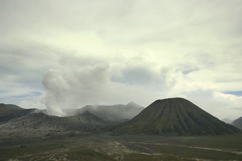
Canon EOS 350D Digital, 1/1250s, f/4.5, 22mm, ISO 200, +4/3EV
the Mt Bromo and Mt Batok as seen from the outer rim of Tennger Crater at Cemara Lawang, Probolinggo, East Java, Indonesia
The hotel offers rooms ranging from the premier ones with balconies facing the volcanoes (about 300,000Rp/night ($32) to the more modest “town” view at half the price. (TIP: At night, the crater and the volcano view disappear in pitch darkness unless the moon is up so check your lunar calendars before getting the more expensive room.)
Whatever your choice, you get free breakfast, hot water, a thick blanket and a heavily quilted jacket, musty I have to admit. You don’t have to bring bulky clothings after all! I didn’t have any. Again, this trip is unplanned. The temperature was in the 15-20C at mid afternoon and frightfully dips below 10C at night. 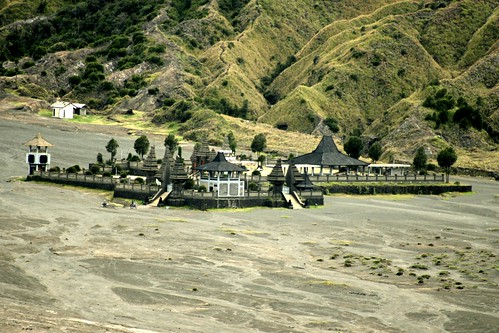
Canon EOS 350D Digital, 1/500s, f/5.6, 300mm, ISO 200
the Hindu temple at the foot of Mt Bromo and Mt Batok as seen from the outer rim of Tennger Crater, Probolinggo, East Java, Indonesia
As it was still 3PM East Java time (or 4PM Bali time), we had time to spare. I decided on a sunset tour which we got for the same amount of $35. The hotel staff almost dissuaded us that the sunset tour was unnecessary as the best “colored” conditions would be during sunrise. However, this was April, a transition month between the rainy season of Jan-March and summertime starting August. I thought that there could be rains and no sun the next morning so we might as well spread the risk and try for the sunset as the sun was sunny that afternoon.
Promptly, we dropped our bags and the guide appeared with a hard top jeep. We were about to embark to our Bromo adventure.
the Bromo sunset
The guide said that it would take us 45 minutes from the entry gate of the National Park to our final destination of Mt Penanjakan. We first crossed the lava plain. Called lautan pasir or the sea of sand, the landscape is nothing short of moon-like. There were no paved roads and “craters” abound, which would not be strange as the crater was a product of a violent volcanic explosion in the past. The ride to Mt. Penanjakan was extremely bumpy and the steep climbs made my stomach lurch. I take it to the driver and to the trusty hard top that we made it to the promontory.
It was 4:30 PM.
The air was thin! At >2,770 meters, Mt Penanjakan which already is part of Pasuruan offers less concentrated oxygen and even the short climb to the viewing deck was killing us. I was literally out of breath by the time we get to the top. Disappointingly, the fog was extremely heavy and I was beginning to question the wisdom of us getting over there. There was one thing going for us. We were alone except for an enterprising boy who was selling local flower bouquets. We decided to wait.
Canon EOS 350D Digital, 1/20s, f/5.6, 47mm, ISO 200, +2/3EV
A boy peddling mountain flowers at Mt Penanjakan, Pasuruan, East Java, Indonesia
The stakeout was excruciating. Almost all of the time, the fog enveloped the entire crater. It was hellishly cold especially when the sun began to disappear. Temperature was obviously below 10C already. My friends complained of lightheadedness and I too could barely feel anything with my fingers. Finally, at around sunset time, at 5:30, the fog began to clear up, intermittently at first. We could get glimpses of the orange light cascading down into the west so I was heartened.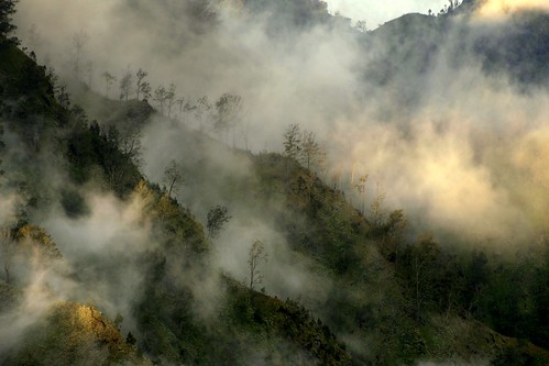
Canon EOS 350D Digital, 1/160s, f/5.6, 170mm, ISO 100
A mountain ridge of Mt Penanjakan, Pasuruan, East Java, Indonesia
phototip: In foggy conditions, watch out for quick shifts of light conditions.
Then suddenly, at about 5:40PM, the fog lifted completely. Multicolored magic had begun.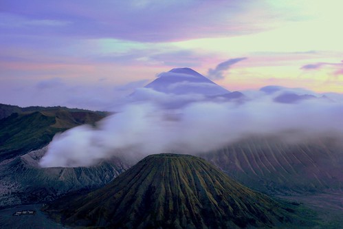
Canon EOS 350D Digital, 25s, f/22, 40mm, ISO 100, +1/3EV
the Tengger Caldera featuring the volcanoes of Bromo, Semeru and Batok in Probolinggo, East Java, Indonesia
phototip: Take different exposures. This was an underexposed shot corrected later on by picasa2 software.
to be concluded in The Road to Bromo, part 3

No comments:
Post a Comment